Thursday, August 12, 2004
In Hurricane Charley's sights

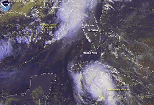
In the box with two hurricanes approaching Florida's west coast, the first time on record that has happened, anywhere, it seems like a good time to do what all good journals do and publish a community advisory, so here goes.
Let me begin by telling you that I've lived and worked on the Gulf Coast now for 8 years and this is our fourth hurricane advisory. That being said I still am not entirely sure what it means. Our County is for the most part at sea level with Florida's densest population and a peninsula with only one major land road to the mainland evacuation is an unlikely option.
In years past a few major storms have touched this part of the gulf coast as they have virtually every other state on the Gulf of Mexico. It comes as no surprise then that locals tend to take storm warnings seriously and make preparations accordingly. Old timers warn of a repeat of the big one in 1935 or the suddenness of the "no name" storm in 93 which killed 26 people in Florida and caused more damage to the US east coast than Andrew.
Storm surge is the heart of the matter. Ocean water pushed by the storm into a bulge rapidly builds as it is squeezed between the storm from behind and the rising sea floor. A two foot swell can quickly rise to 12 feet or more as it breaks over the shore line and onto land. Millions of tons of water moving at upwards of 40 miles an hour rapidly overwhelm and destroy anything in its path. Storm surge is also the least predictable of all aspects of a hurricane, even a miss on land can result in a hit by the surge if tides and wind conditions are right.
As to what constitutes cautionary reaction to a hurricane threat? Obviously,
pay attention to weather warnings and storm predictions. The last 5 years have seen a quantum advance in technology. Fixed earth watch satellites and computer modeling now provide increasingly accurate storm path predictions, but remember that a prediction is just that. At 200 plus miles a variance from center by 70 miles in either direction is equally likely to be the strike zone. At 140 miles the target is wider than the Florida peninsula. At this moment as "Charley moves on shore in Cuba the mouth off Tampa Bay is 200 miles north and dead center the predicted storm path, Bottom line, we'll know better tomorrow.
It's 3:16 in the afternoon and County authorities just ordered the mandatory evacuation of 675,000 residents by 6 PM this evening. In other words the entire county and a good portion of Tampa proper. Our county has a little over 70,000 capacity in shelters and none of those accept companion animals. Authorities urge residents to shelter evacuees in private homes not in the flood area.
A final note regarding the other hurricane, "Bonnie." Bonnie has, within the last hour, gone ashore in the panhandle of Florida and is sending waves of rain into our area 200 miles to the south. These are huge storms even at category 2 and not to be taken lightly. Good night and we'll publish an update tomorrow.
|
|
|
|
|
Comments:
Post a Comment


